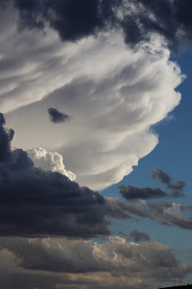
Well... I left the Cabello Lake campground in NM pretty earl y in the morning. I think I was there for about 3 days and two nights. The night before I left there was a thunder storm that hit a little farther north, near Truth or Consequences and I got to watch the storm clouds build through the afternoon and enjoyed the lightning show that night. I took several picture s of the storm and clouds, but the two pics below are m y absolute favorites, I had to share them...
So I pulled out of the campground and and headed north to check out a couple of dispersed camping sites but mostly just to see what was there. I stopped off at the Bosque Apache National Wildlife Refuge area out of curiosity and the sunlight was really emphasizing the colors of the foliage in the fields. I didn't take the whole tour but from what little I saw it was worth the stop...
I found a library about 35 miles north and updated my blog then I checked out several of the camping sites that I had in mind but nothing seemed to suit, and I didn't want to go too far north so I did a turnabout and headed back south and toward Arizona again. I had made the decision already that I didn't care for NM that much, beautiful country , good people, but where I was any way , there were so man y military installations and operations that I just wasn't comfortable there. Example, I was traveling one highway a little off the beaten path and ran up on a sign that said the road ma y be closed from time to time during missile testing... No, not m y kind of place...
Funny thing happened when I got down close to the Mexico border. I picked up interstate 10 headed west at Las Cruces NM and just a few miles up the road there were these huge flashing yellow lights with big signs telling drivers to slow down, the border patrol was just ahead, be prepared to stop.
M y immediate thought was that I had taken a wrong turn and accidentally headed for the Mexican border. Okay I thought, should I turn around? I was desperately trying to get my Google Maps to come up and find out where I was but it was too late, they were stopping all vehicles and turning around at that point would have probably caused me a lot of trouble. So I waited in line as this large Mexican uniformed officer spent time talking to man y of the drivers ahead of me before he let them go.
Here I am in a big white maxi van, perfect for hauling immigrants across the border, so I'm expecting a major search at this point, but when I pulled up to the officer with m y window down, he barely acknowledged my existence only motioning me on past... Whew...
I traveled most of the day and I was getting kind of tired so I started looking for a place to stay for the night. After a few more unfruitful searches I ran up on this place called Indian Bread Rocks campground outside of Bowie AZ. It's a primitive area with a limited number of sites and it was pretty close to the expressway so I figured I would have cell signal but it would still be secluded enough to get away from the cit y.
There was only one other camper parked up by the restroom when I got there. I drove further on down the road but the road got really rough, 4X4 territory , so I managed to turn around and get back out, backing into a small area on the other side of the camping area from the restrooms. I had a great view, there was a spreading mesquite tree right out my side door which blocked me from the neighbor and I got setup.
This place was pretty quiet most of the time and I enjoyed my stay . I did a bit of wood carving and flint knapping the first morning I was there, making a simple Hopi knife, everything came from the surrounding area except the flint, which I keep a supply of for various projects.
I think I was there for a couple of day s before deciding to head out. As I was leaving I took a closer look at what I thought was an orchard but I couldn't seem to identify the trees. They had fruit hanging in clusters on the trees so I pulled off the side of the road and walked over to see what they were. I still didn't recognize them, they had funny shaped fruits, clustered like grapes and probably the size of medium strawberries. The picture is a little fuzzy and the light wasn't good, but you can see the clusters of fruit on the tree, and the next pic just shows one of the orchards, there were many orchards with trees at different ages and stages of development. What keyed me in to what the fruits were was a street in-between two orchards and it was labeled 'Pistachio Road'... I have never seen a pistachio tree before, nor what the fruits look like, so I Googled them just to make sure and yep, that's what they were.
Next I headed kind of north west, heading basically in the direction of Flagstaff AZ. Google maps... yep, I have a relationship with this woman, and most of the time it's challenging, she told me to take this highway that was shorter. Not that I was in a rush, but I did want to drive different roads back toward Flagstaff, just for the heck of it.
So I took the bait. Oh man... this is a beautiful stretch of highway, bu t the steep inclines and the winding two lane roads right next to the mountain bluffs, it was an adventure for sure. I stopped at one overlook to snap a few photos...
This one you can see that there are no guardrails, no fences, I just walked out as far as I dared to take the photos, but there was nothing but a straight drop below me and it did make me a bit uncomfortable...
Below are just a couple more I snapped while I was there, the sun wasn't in a good position, but the views are just spectacular...
And the one below if you look carefully you can see the highway and vehicles winding their way through the mountains...
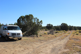
As I made my way into the Flagstaff area, I was looking for a camping sites to spend the night. I wanted to be out of town enough to avoid the weekend warrior crowds, and I came up on this dispersed camping area in the Coconino National Forest. There wasn't any other campers around, but there was a public firing range about 4 miles further down the road, so I veered off on a dirt side road and found this nice quiet area to camp. I couldn't go an y farther back because the roads at that point were only passable with a 4X4.
As I got out and wandered around the area I found lots of fresh moose tracks and skat (moose poo). In fact the photos of the hoof prints below were taken 10 feet from the van, and the skat I found was about 15 yards behind me. I also found two sun-bleached animal carcasses in the field behind me, so I included a picture of one of them, aren't you happy, but the only moose I actually saw was one that was crossing the road ahead of me while I was driving, making my way back to the highway. I couldn't get my camera out quick enough before he disappeared, so no pic...
That night I heard the usual coyote howls in the distance, and not much else, but in the morning I awoke to the strangely soothing sound of moose mating calls. It kind of sounded like whales on the ocean, and I have to admit, that was pretty cool. I stayed there a couple of nights and managed to get a lot done on the van. The weather for the most part was cooler than southern AZ, I think I was at about 6000 feet elevation, so the winds blew strong and gusty most of the time when the sun was up with 70's during the day and 40's at night. Good sleeping weather..
I'm now in another part of the Coconino forest south of Flagstaff, I'll update the blog the next chance I get...
In Native American culture, the appearance of random white feathers signifies rebirth and new beginnings. I have recently retired and decided to travel the states, living on the road in my customized 2003 Dodge conversion van (aptly named Anastasia, her Indian name is White Feather). For at least the next couple of years we will be wandering nomads of the earth. Seeking only a deeper connection with nature. This will be our travel journal...
Subscribe to:
Post Comments (Atom)
The Invitation
A close friend of mine sent this to me and it just blessed me when I read it. I thought it was so beautiful and I wanted to share. To ...
-
A close friend of mine sent this to me and it just blessed me when I read it. I thought it was so beautiful and I wanted to share. To ...
-
There are so many varied thoughts and ideas that arise while in solitude. Those most persistent are related to past relationships. I s...


No comments:
Post a Comment